Surveillance system covering 4,406 islands set up
Updated: 2013-04-21 00:22
(Xinhua)
|
||||||||
BEIJING - China has established a national island surveillance and monitoring system and completed airborne remote-sensing surveillance of its 4,406 islands, according to the Ministry of Land and Resources (MLR).
The national system is mainly built on aerial surveillance, with satellites, unmanned planes and cruisers as auxiliary instruments, the MLR said in its annual land resources report issued Saturday.
Since a national plan on island protection and exploration came into effect in last April, south China's Zhejiang, Fujian, Guangdong provinces and Guangxi Zhuang Autonomous Region have passed their own provincial-level scheme, with Liaoning, Hebei, Shandong, Jiangsu and Hainan completing their draft plan, the ministry said.
Last year, China completed an island name survey, including on-site investigation on part of the atolls in the three island groups known as Sansha in the South China Sea.
The country also released the standard names and geographical coordinates of the Diaoyu Islands and its affiliated islands in the East China Sea, as well as other geographical entities in their surrounding waters last year, according to the MLR report.
- China continues to patrol Diaoyu Islands
- Navy patrols Diaoyu Islands on treaty anniversary
- PLA Naval fleet patrols Diaoyu Islands
- China to exhibit mineral found near Diaoyu Islands
- Chinese ships patrolling near Diaoyu Islands
- Developing Hainan as intl resort island: Xi
- Xi stresses Hainan's development as resort island

 Chinese victims' families arrive in Boston
 Chinese soldiers clear mines, win hearts
 More bird flu patients discharged
 Credibility still top concern for Chinese firms
 Every second counts in rescue
 Soldiers bring hope to earthquake-battered region
 Premier visits quake-affected in hospital
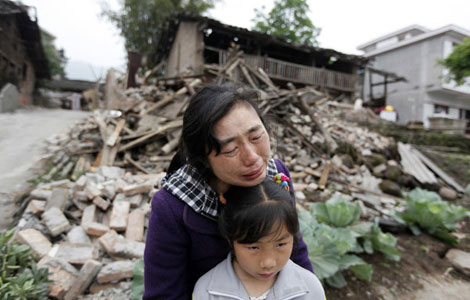 Quake-affected people lose homes
Most Viewed
Editor's Picks
|

|

|

|

|

|
Today's Top News
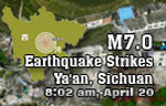
Live report: 7.0-magnitude quake hits Sichuan
Chinese soldiers clear mines, win hearts
Intl scholarship puts China on the map
More bird flu patients discharged
County struggles to recover
Telecom workers restore links
Relief materials to reach quake zone
Govt: faster transfer for foreign quake aids
US Weekly

|

|