Beidou system to aid Belt and Road
Updated: 2015-06-02 07:46
By Zhao Lei(China Daily)
|
||||||||
Chinese satellite platform provides functionality that will meet needs around globe, top designer says
The Beidou Navigation Satellite System will help China carry out the Belt and Road Initiative, according to senior project officials.
Yang Changfeng, chief designer of the Beidou system, told China Daily that the Belt and Road Initiative have created a perfect platform and opportunity for the Beidou system to promote itself globally.
"The central government has included the system in the initiative's strategic plan, with top leaders repeatedly asking us to speed up the internationalization of Beidou to serve the development of China and other nations," Yang said.
The Belt and Road Initiative, a development strategy proposed by China in 2013, refers to the Silk Road Economic Belt, which will link China with Europe through Central and Western Asia, and the 21st Century Maritime Silk Road, stretching from southern China to Southeast Asia, and even to Africa.
"To date, the Beidou system has covered most parts of the Asia-Pacific region as well as countries along the Silk Road Economic Belt and 21st Century Maritime Silk Road," Yang said.
"It will offer Beidou-based navigation or positioning services to these nations in terms of cross-border transportation, fishing management, customs clearance and modern agriculture."
Ran Chengqi, director of the China Satellite Navigation Office, which oversees the Beidou project, said China is cooperating on satellite navigation with a host of countries, including Australia, Indonesia, Pakistan and Singapore.
"We are helping some countries in Southeast and South Asia plan for their ground applications of the Beidou system. We are also helping them build infrastructure so they can better use the system," he said.
China launched the first Beidou satellite in 2000. The system began providing positioning, navigation, timing and short-message services to civilian users in China and surrounding countries in the Asia-Pacific region in December 2012. The system now has 16 satellites.
Beidou is the fourth navigation satellite system in the world after the United States' GPS, Russia's GLONASS and the European Union's Galileo.
The latest satellite in Beidou's space network was put into orbit on March 30, marking the first step in expanding the network from a regional service to global coverage. The new-generation Beidou satellite has begun to test the new navigation signaling mechanism and intersatellite links.
China will launch up to four satellites for the Beidou network before the end of this year. The new-generation satellite has a longer life - at least 10 years compared to eight years for the old model. It also has higher accuracy - 2.5 meters rather than 10 meters.
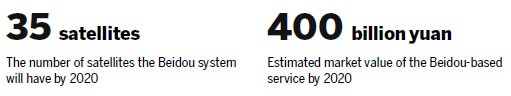
According to the government's plan, the Beidou system will have 35 satellites by 2020, five of which will be in geostationary orbit.
Huge market
In 2013, the State Council published a long-term development plan for the satellite navigation industry, promising to boost Beidou's application in the civil sector. Under the plan, it is estimated that the market value of the Beidou-based service will reach 400 billion yuan ($64.4 billion) by 2020.
However, the system's current share of the domestic satellite navigation and positioning market is less than 10 percent, according to official statistics. The China Satellite Navigation Office hopes that Beidou will have at least a 30 percent market share in 2020.
Having realized the huge potential of Beidou-based service and devices, Chinese enterprises are pouring in investment to tap the market.
Huawei, one of the global telecom giants, has launched several mobile phones that have Beidou-based apps. Chinese carmakers also mount Beidou devices on about 200 types of cars.
Li Kang, sales director at Wuhan Exsun Beidou Space Technology Co in Hubei province, said the company has benefitted from the government support for the Beidou-based service.
"Transportation authorities have ordered that all heavy-duty trucks and long-distance buses must have a positioning device compatible with the Beidou system.
"Meanwhile, following government instructions and financial assistance, nearly all fishing boats in China have installed Beidou equipment," he said. "We are witnessing the formation of a vast Beidou service market, which in turn will provide many business opportunities for us." Beidou allows users to send short text messages to another Beidou device, he added, unlike the US GPS.
Wang Yiwei, manager of development planning at CETC Satellite Navigation Operation and Service Co in Hebei province, said Beidou's text messaging function is very popular among fishermen and disaster rescue workers in China.
"Many places where they work have no telecommunication signals, so the Beidou device is the only way they can reach the outside," he said. "Compared with the expensive satellite phone service, Beidou's text messaging is free of charge and allows the user to send up to 60 Chinese characters."
Wide application
Wang Chang, general manager at Shanghai ComNav Technology Co, a Beidou device manufacturer, said his company invented Beidou-based positioning equipment that can be installed on planters and crop harvesters.
"Farming vehicles equipped with the device will be able to automatically operate without human control, which means high efficiency. That is very useful on large farms," he said.
Li Jian, general manager at Shanghai West Hongqiao Navigation Industry Development Co, suggested that the government should introduce more favorable policies for Beidou-based equipment and services to encourage more industries and people to use them and help enterprises reduce their production costs.
"The high cost of a Beidou device is a major obstacle. The prices of some Beidou equipment are several times higher than those for GPS," he said.

Ran said that to promote Beidou overseas, China has been making every effort to turn the Beidou network into a universal platform.
"The International Maritime Organization included our Beidou system in the Worldwide Radionavigation System in November, after GPS and GLONASS," he said.
"We are now pushing ahead with the airworthiness certification for Beidou's airborne equipment, hoping it can be accepted by the International Civil Aviation Organization within five years," he said.
A Transport Ministry official, who did not want to be named, said inclusion of Beidou in the Worldwide Radionavigation System was an important step in the system's adoption by the global maritime sector, as the IMO stipulates that its members' ships must carry a satellite navigation receiver.
"With the IMO's support, it will be much easier for the Beidou system to be adopted by foreign shipping companies," she added.
Li Yue, director of the 20th Institute of the China Electronics Technology Group Corp, said the institute, which specializes in navigation technology, has invested heavily in development of an indigenous ground-based augmentation system that is essential for airport navigation operations.
"Our system is being tested at several domestic airports, and the initial results are satisfying," he said. "We plan to put it to the market by the end of this year. We are also working on the Beidou-based airborne equipment, hoping it can be used on China's domestically developed airliners."
zhaolei@chinadaily.com.cn
|
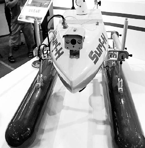
A model of an unmanned vessel equipped with the Beidou navigation system is displayed at the 9th China-Asean Expo in Nanning in the Guangxi Zhuang autonomous region in September. Zhang Ailin / Xinhua |
(China Daily 06/02/2015 page5)

 National college entrance exam ends in most parts of China
 Peking University opens Chinese traditional art courses
 Rescuers mourn victims on seventh day since Eastern Star disaster
 Rescuers enter Eastern Star hull in search efforts
 Gaokao held across China
 Man sues actress for staring at him
 Students prepare to take national college entrance exams
 Across America (May 29- June 4)
Most Viewed
Editor's Picks

|

|

|

|

|

|
Today's Top News
China gives its yuan to Broadway
Questions remain unresolved in the cruise ship disaster
Escaped New York prisoners may have had help from staff
Memphis hospital adds new China affiliate
Police alerted over forbidden photo shoot
Heavyweight Zhang wins unanimous decision
China mourns Yangtze shipwreck victims as search continues
China signs $50m agreement with FAO to support developing countries
US Weekly

|

|