Heritage
Center to use remote sensing for heritage site protection
Updated: 2011-07-29 08:01
By Wang Ru (China Daily)
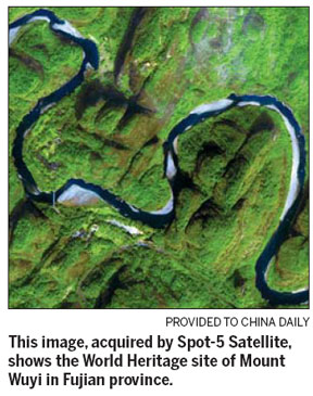
The newly launched Space Technologies for Natural and Cultural Heritage (HIST) center under the Chinese Academy of Sciences (CAS), will apply space and remote sensing technologies for the observation, documentation and conservation of UNESCO World Heritage sites.
"This is a new field of action," Dr Mario Hernandez, senior program specialist for remote sensing activities in UNESCO, says.
"It can help monitor the changes in world heritage sites, contribute significantly to the enforcement of international rules, to better define local/national legislation, and facilitate policy making."
Since 2001, UNESCO has been working with the European Space Agency to use high-resolution satellite images to monitor natural and manmade changes to world heritage sites, especially in developing countries that lack space technologies.
It has played a key role in the safeguarding of gorillas' habitats in Central Africa and in monitoring world heritage sites in Pakistan, during the disastrous floods of 2010.

"It is important to help developing countries identify, document and preserve the world's heritage, by selecting a list of natural and cultural sites whose outstanding values should be preserved for all humanity," Gretchen Kalonji, assistant director-general of UNESCO, says
Currently, UNESCO has 812 world heritage sites and the world body should ensure their protection through closer co-operation among nations, she says.
"China boasts plenty of natural and cultural heritage sites, as well as developed space technologies. UNESCO believes China should play a leading role in this field," she says. "We greatly appreciate the partnership that UNESCO has with the Chinese Academy of Sciences."
HIST is based in, and supported by, the Center for Earth Observation and Digital Earth (CEODE) in Beijing, a research institute affiliated with CAS. It is responsible for the acquisition, processing, archiving and distribution of remote sensing data.
HIST will assist UNESCO by providing remote sensing data, deriving results from the data to support decision makers and analyze the impact of tourism, natural disasters and climate change.
Professor Guo Huadong, CEODE's general director and also the HIST director, says the new center will introduce space technology for the monitoring of world heritages sites in China and other Asian countries.
From 2010 to 2011, HIST will build a global satellite imagery database for all of UNESCO's world heritage sites. Later, it will help other developing countries through the transfer of remote sensing technology and by providing training.
"We have the experience and technology to support the project," says Guo, who referred to the successful monitoring and protection of the Great Wall on the basis of satellite images.
"The establishment of HIST opens a new platform for cooperation to protect world heritage sites. CAS will continue to develop its space technology to strengthen this cooperation," Ding Zhongli, CAS vice president and chairman of the HIST Committee, said at the opening ceremony on July 24.
It was in 2007 that CAS submitted a proposal to UNESCO to establish HIST. It received approval in 2009 at UNESCO's 35th session. In 2011, the State Council of China formally approved the cooperation. In early June, UNESCO's director-general Irina Bokova and CAS president Bai Chunli signed the agreement to establish HIST.
China Daily

Specials

Wen pledges 'open' probe
Design flaws in the signal equipment led to Saturday's fatal high-speed train collision, authorities say.

Turning up the heat
Traditional Chinese medicine using moxa, or mugwort herb, is once again becoming fashionable

Ciao, Yao
Yao Ming announced his retirement from basketball, staging an emotional end to a glorious career.