True history of Diaoyu Islands
Updated: 2013-05-21 08:18
By Zheng Hailin (China Daily)
|
||||||||
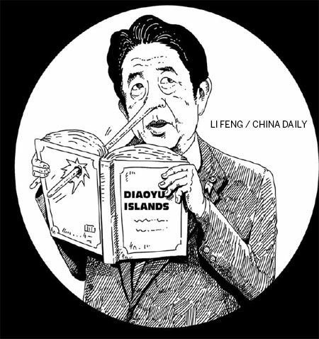
Unilateral actions taken by Japan since last year, including the decisions to "purchase" and "nationalize" the Diaoyu Islands, have pushed Sino-Japanese relations to their lowest point in four decades.
Japan claims that the Diaoyu Islands were terra nullius before it discovered and incorporated it into the Japanese territory. But the truth is, decades before Japan annexed the Ryukyu Kingdom - and occupied the Diaoyu Islands - British naval ships had to obtain permission from the then Chinese government before even entering the waters off the Chinese islands in the East China Sea, including the Ryukyu Islands and the Diaoyu Islands.
To anchor its ships off the coast of the islands, the British navy had to submit applications through the Liuqiu guan, or the Ryukyu consulate in Fujian province, which then redirected them to the Buzhengsi, or the Fujian provincial chief secretary for administration, for approval because of the tributary relations between Ryukyu and China.
According to The Historical Analyses of the Diaoyu Islands by Japanese academic Kiyoshi Inoue, British naval vessel Samarang set sail from the Ryukyu Kingdom's Yaeyama Islands and Yonaguni Island and reached the Ishigaki Island on June 14, 1845. On that fateful night, captain Edward Balcler unfolded a nautical chart to locate Hoapin-San, today's Huaping Isle, to conduct a survey of the hydro-geographical features of the waters between Huaping Isle and the Diaoyu Islands.
On June 15, the ship reached Tiau-Su, or the Diaoyu Islands, but mistook it for Hoapin-San. The survey results were published in 1848 in the Narrative of the Voyage of HMS Samarang during the Years 1843-46, which is perhaps the earliest scientific survey report on the Diaoyu Islands.
In 1855, the British navy drafted and published a nautical chart based on the report, and included the chart in The Islands between Formosa (Taiwan) and Japan with the Adjacent Coast of China.
The voyage of the Samarang is also supported by circumstantial evidence from the Chronicle of Ryukyu. According to the chronicle, the captain of the Samarang had applied to the Fujian provincial commissioner through the British consulate as well as the Ryukyu consulate in Fuzhou, capital of Fujian, and got the necessary approval before setting sail for the survey.
The chronicle says that in late 1844, George Tradescant Lay, British consul to Fuzhou, handed the "documents" to Ryukyu's consul in Fujian, which said that the Queen of the United Kingdom and the Emperor of Qing Dynasty (1644-1911), being desirous of ending the misunderstandings and consequent hostilities between the two countries, have resolved to conclude a treaty for that purpose.
Another official letter was addressed to Ryukyu, which conveyed Lay's commitment to friendly ties between the UK and the Ryukyu Kingdom, as well as the concerns over the livelihood of Ryukyu residents, which might have been disrupted by British anti-piracy and survey activities. The letter added that if the British crew needed daily supplies, local residents should provide them with the same after charging them the market price.
In 1845, a foreign ship appeared in the waters off the Yonaguni Island. In the following three days, five people visited the island, planted a white flag there and used a telescope to survey the surrounding areas. On the fourth day, 11 foreigners and a Chinese reached the island in a sampan. A local resident who had learned the Chinese language ran into the newcomers and asked them where they had come from. The Chinese told him that the ship belonged to the UK and there were some 200 people on board. This happened in the fifth lunar month of the year, which corresponds to the Gregorian calendar's date when the Samarang set sail.
Also, in the summer of 1845, the Ryukyu consul in Fujian forwarded the letter from the British consul and delivered messages to the home country, which said that the UK and Ryukyu had been on good terms, and the British side had already conducted surveys in the waters off the Yaeyama Islands since 1843. But now that Ryukyu had been informed, it should turn down the British side's request and prevent the ship's crew from carrying out further surveys. Besides, it would be inappropriate not to report the matter to the provincial commissioner in Fujian.
These events of 1845 took place 34 years before Japan annexed Ryukyu and are confirmed by historical records both from the British navy and the Ryukyu Kingdom. They are undeniable proof of the Diaoyu Islands being an integral part of Chinese territory since ancient times.
Before Japan annexed Ryukyu, the British had to apply to the Fujian provincial commissioner via the Ryukyu consulate in Fuzhou, which meant they had to obtain permission from the then Chinese government instead of directly seeking approval from the Ryukyu Kingdom to conduct surveys in waters off the Diaoyu Islands. The documents also prove that before Ryukyu was annexed, Ryukyu residents as well as the British accepted that the Diaoyu Islands belonged to China.
More importantly, seen from the nautical chart used by the Samarang's captain, the names of the Diaoyu Island and its affiliated islets were based on the Fujian dialect, indicating that China, instead of Japan, first discovered them, assigned them names and exercised jurisdiction over them.
The author is a researcher at the Hong Kong Institute of Asia-Pacific Studies, the Chinese University of Hong Kong.
(China Daily 05/21/2013 page9)

 Michelle lays roses at site along Berlin Wall
 Historic space lecture in Tiangong-1 commences
 'Sopranos' Star James Gandolfini dead at 51
 UN: Number of refugees hits 18-year high
 Slide: Jet exercises from aircraft carrier
 Talks establish fishery hotline
 Foreign buyers eye Chinese drones
 UN chief hails China's peacekeepers
Most Viewed
Editor's Picks

|

|

|

|

|

|
Today's Top News
Shenzhou X astronaut gives lecture today
US told to reassess duties on Chinese paper
Chinese seek greater share of satellite market
Russia rejects Obama's nuke cut proposal
US immigration bill sees Senate breakthrough
Brazilian cities revoke fare hikes
Moody's warns on China's local govt debt
Air quality in major cities drops in May
US Weekly

|

|