China issues top alerts on typhoon Kai-Tak
Updated: 2012-08-16 21:03
(Xinhua)
|
||||||||
|
 |
|
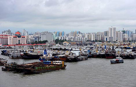
Ships are seen anchored at a port in Haikou, South China's Hainan province, Aug 16, 2012. [Photo/Xinhua] |
BEIJING - Chinese marine environment authorities upgraded the alert about sea waves and storm surges to the highest level of red for the approaching typhoon Kai-Tak on Thursday afternoon.
The move was made at 4 p.m., eight hours after the previous upgrade in the morning, the National Marine Environmental Forecasting Center said in a report.
The center uses a four-tier color-coded wave warning system, with red being the most severe, followed by orange, yellow and blue.
Typhoon Kai-Tak, the 13th of this year, was about 600 km to the southeast of Zhanjiang city of Guangdong province at 2 p.m. and was expected to hit the coastal area of southern Guangdong on Friday, at noon or during the afternoon, said the report.
It forecast that from Thursday evening to Friday, northern waters in the South China Sea will produce waves six to eight meters high, while waters off coastal areas in Guangdong will see waves four to six meters high.
The neighboring Hainan and Guangxi provinces will also witness 2.5- to 3.5-meter-high waves during the same period, according to the forecast.
The center also issued a red alert of storm surges at the southern coastal area of Guangdong, with a forecasted surge of 50 to 250 cm from Thursday evening to Friday afternoon.
The center warned local authorities and the public to take precautionary measures and intensify safety checks on fishing facilities.
Earlier on Thursday, the China Meteorological Administration (CMA) also raised its emergency response on Kai-Tak to Level II from IV.
![A border policeman directs a ship before the approaching typhoon Kai-Tak in Zhongshan, South China's Guangdong province, Aug 16, 2012. [Photo/Xinhua] China issues top alerts on typhoon Kai-Tak](../../attachement/jpg/site1/20120816/d4bed9d5345511973d7e27.jpg) |
|
A border policeman directs a ship before the approaching typhoon Kai-Tak in Zhongshan, South China's Guangdong province, Aug 16, 2012. [Photo/Xinhua] |
The CMA forecast that Kai-Tak would cause heavy rain and gales in coastal areas.
The southern part of Guangdong will be hit hardest as precipitation in some regions is expected to reach 250 to 300 mm, while areas of southern Fujian and Guangxi, most parts of Guangdong, and northern Hainan will see strong downpours, said the CMA report issued at 9 a.m. on Thursday.
The CMA urged local governments to monitor possible flooding and landslides in mountainous districts, as well as helping evacuate dilapidated housing and halting massive rallies to avoid casualties.
It also asked local flood control authorities to call back ships and reinforce port facilities to mitigate economic losses.
Since the start of August, several typhoons, including Saola, Damrey and Haikui, have hit southeast China, leaving 51 dead and 21 missing, according to the country's Ministry of Civil Affairs.


