China maintains top-level alert for Typhoon Soulik
Updated: 2013-07-13 14:59
(Xinhua)
|
||||||||
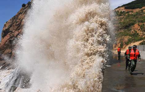
BEIJING - The National Marine Environmental Forecasting Center on Saturday maintained a top-level warning for sea waves caused by Typhoon Soulik.
The typhoon is expected to make landfall on the Chinese mainland's Fujian province Saturday afternoon, the center said, warning that as it approaches, sea waves and tide levels in waters near Fujian and Zhejiang provinces will be higher.
The center issued a red wave alert and an orange alert for storm tides.
During Saturday daytime and night, Soulik is expected to whip up sea waves as high as 6 to 10 meters in the southern part of the East China Sea, waters near the Diaoyu Islands and the northern part of the Taiwan Straits.
Sea waves at some monitoring sites have reached high levels. The highest wave, measuring 13.1 meters high, was observed by a monitoring facility in waters near the Diaoyu Islands.
Moreover, waters near Zhejiang and the northern part of Fujian may see waves of 4 to 6.5 meters.
The center warned ships in the affected regions to take safety measures and told relevant organizations to take precautions against high sea waves.
Authorities were also urged to carry out inspections and maintenance for wave protection facilities.
China uses a four-tier color-coded weather warning system, with red representing the most severe weather, followed by orange, yellow and blue.
Related stories:

 Residents flee from landslides
 Inscriptions may predate oracle bones
 Coca-Cola seeks to connect with young customers
 Tourists say they aren't afraid to travel in Xinjiang
 Summer lights
 BASE jumpers celebrate their annual event
 S Korean students mourn Chinese victims of air crash
 Constructive mood at talks
Most Viewed
Editor's Picks

|

|

|

|

|

|
Today's Top News
3rd Chinese girl dies in Asiana crash
Snowden seeks asylum in Russia
IT push to boost domestic demand
Key investment negotiations to restart
Chinese companies in the US go on talent hunt
More women turning to abortions
Nokia aims to recapture market
Samsung expands global footprint
US Weekly

|

|
![Giant waves surge up against the shoreline in Sansha town, Fujian province, on July 13, 2013. [Photo/Xinhua] China maintains top-level alert for Typhoon Soulik](../../attachement/jpg/site1/20130713/0023ae6cf369134b2fbb03.jpg)


