GPS helps the visually impaired cross French mountains
Updated: 2015-07-10 07:30
By Agence France Presse in Reipertswiller, France(China Daily)
|
||||||||
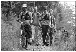
Five hikers, all blind or partially sighted, crossed a mountain range in eastern France recently thanks to an innovative GPS system that developers hope can help millions of people with vision problems.
Armed only with their white canes and the experimental smartphone app - unaccompanied by sighted guides - the group trekked 80 kilometers in six days through fields and forests in the Vosges range near the German border.
Worn in a small pouch over the stomach, the Navi'Rando - named after "randonner", the French word for hiking - warned of bends in the path and turning points at regular intervals.
Developed by a team at Strasbourg University in northeastern France, it is part of a growing trend tapping the power of technology to improve life for the visually impaired.
"Point 15, 11 o'clock, 194 meters," it says in a jerky electronic voice, meaning in just under 200 meters, turn slightly left in the direction of "11 o'clock".
Volunteers from the French Hiking Federation programmed a precise itinerary for the group beforehand, taking care to note any obstacles on the path.
"The thing that's still difficult is using the cane to locate the exact direction of the trail," says Jean-Claude Heim, who has been blind since birth.
"You really have to concentrate," says the 63-year-old former teacher, a regular hiker though the Vosges was his first trail without a sighted partner. But that didn't stop him from enjoying "everything the countryside has to offer: the smells, the sensation of touch, the rain, the sound of the birds".
For Nicolas Linder, 30, the advantage of the device was its boost to self-confidence and autonomy.
"It's fantastic to rediscover your sense of freedom," he says as he sweeps the path with his white cane.
Among visually challenged people, "95 percent of them have problems leaving home" without assistance, he says.
For Navi'Rando's developers, the Vosges mountain crossing was a major test.
Though not the first researchers to use GPS systems to help the blind, the Strasbourg system "is the first to use inertial measurement units to refine the GPS signal and regularly recalculate the itinerary", says team member Laurence Rasseneur of the university's sports science department.
An IMU is an electronic device with gyroscope, barometer and accelerometer functions to aid navigation. It's used to help guide aircraft, including the unmanned variety.
"The next step is to make sure this system will work anywhere, even in places where it can't pick up a GPS signal," says Jesus Zegarra, an electronics engineer who has worked on the project for five years.
The Strasbourg device already works in the streets.
"With this, I can allow myself to concentrate a bit less - I don't have to count my steps to know when exactly to change direction," says Clement Gass, who is partially-sighted and walks to work on his own every day in Strasbourg.
On June 13, the sporty 27-year-old used the Navi'Rando to achieve a world first: running a 26-km trail along with more than 200 sighted participants.
Rasseneur, however, sees more than just navigational potential.
"We hope this technology will help change people's perceptions about the handicap and improve employment opportunities for the visually impaired," she says.
The project is still at the experimental stage but its developers hope to train and equip greater numbers of blind and partially sighted people with the device, both in France and other countries.
At this stage, "the challenge is not technological, it's human", says Rasseneur. "It's a cultural revolution so we need pioneers to show that it's possible."
|
People with visual impairment take part in a hike with a white cane and a GPS device using voice navigation in eastern France.AFP |
(China Daily USA 07/10/2015 page15)
- FARC announces new unilateral ceasefire
- Everyone safe on returned A380 flight in Amsterdam
- SCO summit to take up India's membership
- Myanmar president pledges to hold clean, free, fair election
- S.Korea keeps record-low rate on hold after MERS outbreak
- Xi, Putin agree to actions on connectivity proposals

 Plane makes emergency landing after fire
 Ten photos you don' wanna miss - July 8
 Female robot sings in Shanghai
 Stunning images of Tibetan Buddhist pilgrims
 Then and Now: Beijing’s historic sites as witnesses of war
 In photos: China from above
 Serena Williams beats sister Venus to reach last eight
 Culture insider: Six things you may not know about Minor Heat
Most Viewed
Editor's Picks

|

|

|

|

|

|
Today's Top News
IMF keeps 6.8% growth for China; sees little effect from stock market
Yuan hit by turmoil in the market
SCO summit to take up India's membership
Xi, Putin agree to actions on connectivity proposals
IMF urges boost to development finance
China shares listed in US see selling
US orchestra to play China
China answers Clinton charges
US Weekly

|

|