Satellites of many countries aiding search
Updated: 2014-04-25 07:10
By Zhao Lei (China Daily)
|
||||||||

China has been given access to nearly 700 satellite images from other countries in the search for Malaysia Airlines Flight MH370, after invoking an international charter agreement designed to pool space resources in time of need, the China National Space Administration said.
The administration called for help under the International Charter on Space and Major Disasters on March 11, three days after the flight disappeared en route from Kuala Lumpur to Beijing, and coordinated satellites owned by various nations, including the United States, France, United Kingdom and Germany, to examine areas where the ill-fated plane could be.
It was the first time the charter had been invoked to coordinate assorted corporate, national space agency and international satellite assets to search for an aircraft.
Since the call for help, hundreds of images taken by foreign satellites have been given to China to support the multinational search.
China's resort to the charter's mechanisms was revealed by the space administration after an international conference in Beijing last week, dealing with further development of the charter. Fifteen signatories including the US National Oceanic and Atmospheric Administration, Indian Space Research Organization and Japan Aerospace Exploration Agency attended.
The charter's website indicated that the US Earth observation satellites Landsat-8 and Terra, as well as the high-resolution radar satellite TerraSAR-X, a joint venture of the German Aerospace Center and EADS Astrium, took part in the hunt for MH370.
China has designated 21 satellites to search for clues on the whereabouts of MH370, but no solid traces have been detected so far. China signed the charter in May 2007 and first invoked the mechanism's assistance two months later when a series of devastating floods ravaged a large part of China's central and eastern regions.
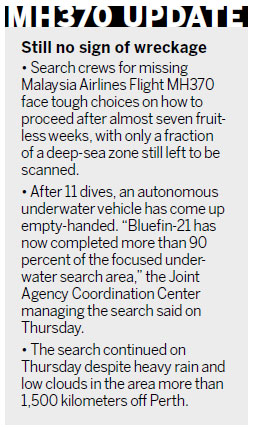
The country has called for assistance under the charter 17 times and obtained large amounts of satellite data to facilitate disaster relief efforts, the administration said.
The last time China resorted to the charter was in August when the most devastating floods in five decades hit northeastern China. The German Aerospace Center, Canadian Space Agency and US Geological Survey delivered images produced by their satellites to China.
For its part, the country has offered satellite data to help handle the forest fires that afflicted southeastern Australia in 2009, the floods that ravaged Pakistan in 2010 and the earthquake and tsunami disasters that struck Japan in 2011.
China has also assigned the high-resolution Earth observation satellite Gaofen-1 and weather satellite Fengyun-3C to be on duty for the charter to replace their predecessor, Shijian-9A.
"The cooperative mechanism has contributed a lot to global efforts to relieve and prevent huge losses from natural disasters," said Wang Ya'nan, deputy editor-in-chief of Aerospace Knowledge magazine in Beijing. "It can also be of great help in multinational emergency response, such as the search for MH370."
The next steps for the charter, he said, should be to expand international cooperation to more fields and to include more parties that have space capabilities.
zhaolei@chinadaily.com.cn
(China Daily 04/25/2014 page5)
 China calls on talent worldwide
 Celebrated sculptor seeks to establish art museum
 Multilateral drill marks navy's 65th birthday
 MOCA to open Chinese ink show
 US sends troops to Poland for exercises
 French 'spiderman' scales 33-story building in Macao
 2014 China Graduate Fashion Week in Beijing
 Top 10 celebrities driving auto brands
Most Viewed
Editor's Picks

|
|

|
|

|
|
Today's Top News
A window into China's big dilemmas
Celebrated sculptor seeks to establish art museum
China calls on talent worldwide
Infrastructure opening to foreign investors
Supreme Court ruling mixed news for SCA-5
Top Chinese legislator meets U.S. House majority leader
Obama criticized for Diaoyu Islands remarks
Opinion: Asia's future at risk
US Weekly

|

|