Beautiful China
Updated: 2014-08-30 11:10
(China Daily)
|
||||||||
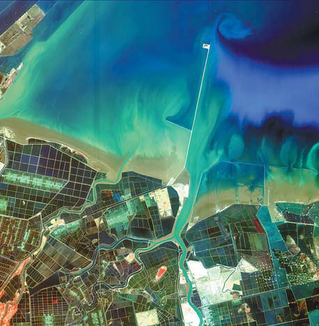
Photos by State Administration of Science Technology and Industry for National Defense and Chinese Academy of Sciences
Gaofen-1 is a satellite launched last April as part of the country's HD Earth observation system. These images that show the natural landscape of China are captured by the satellite.
Gaofen-1 has an imaging resolution of 1 meter; while the world record is held by DigitalGlobe, the precision of whose WorldView-2 that participated in the search for MH370 is 0.5 meter.
The activation of the Gaofen-1 satellite marks a milestone in a program that will substantially improve the nation's capabilities in disaster relief, surveying and environmental protection, says the State Administration of Science, Technology and Industry for National Defense, which oversees the program.
The satellite is also widely used in geographic and resource surveys, climate-change monitoring, precision agriculture and city planning. Chinese police have used the Gaofen-1 Satellite database to discover illegal border crossings, it is reported.
|
The beach in Dongying, East China's Shandong province. |

 Star Stefanie Sun holds concert in Beijing
 Faye Wong's manager refutes star's drug rumors
 Lu Yi and daughter Bei Er pose for street snaps
 Photoshoots of actress Li Xiaomeng
 Council of Fashion Designers of America Awards
 Fan Bingbing, first Chinese actress in Barbie Hall of Fame
 Awarding ceremony of 2014 hito Pop Music held in Taipei
 Zhao Liying's photo shoot for Children's Day
Most Viewed
Editor's Picks

|
|
|
|

|

|
Today's Top News
Beijing spruces itself up for APEC summit
New Budget Law to change the game
Microsoft asked to explain monopoly accusations
China makes largest share of foreign students
Chinese American to run NYC public schools' fund
US launches fresh air strikes on IS rebels
NPC decision a landmark in HK democratic development
Chui Sai On elected Macao chief executive-designate
US Weekly

|

|