China issues thematic map on Diaoyu Islands
Updated: 2012-09-18 20:38
(Xinhua)
|
||||||||
BEIJING - China issued on Tuesday a thematic map on the Diaoyu Islands and its affiliated islands.
The map is compiled and issued by the SinoMaps Press, announced National Administration of Surveying, Mapping and Geoinformation.
Chinese Foreign Ministry spokesman Hong Lei said at Tuesday's routine press briefing that the issue of the map is another concrete measure taken by the Chinese government to enhance its administration of the Diaoyu Island and its affiliated islands.
Last Saturday, China's State Oceanic Administration (SOA) released a string of geographic coordinates of the Diaoyu Island and some of its affiliated islands, including the exact longitude and latitude of the Diaoyu Island and 70 of its affiliated islands. It also publishes location maps, three-dimension effect graphs and sketch maps for the Diaoyu Islands.
The announcement aims to help the public understand the information concerning the Diaoyu Island and its affiliated islands, the SOA said in a statement on its website.
- There should be no provocation over Diaoyu Islands
- Chinese representations over Japanese landing on Diaoyu Islands
- Famous names join Diaoyu Islands protest
- Two Japanese land on Diaoyu Islands: govt
- Diaoyu Islands Defending Forum opens in Jakarta
- China to offer fishing services off Diaoyu Islands
- China announces geographic codes for Diaoyu Islands
- Super typhoon Sanba approaching Diaoyu Islands
- Vessels patrol Diaoyu Islands
- Diaoyu Islands 'Purchase' reflects weakened Japan: experts
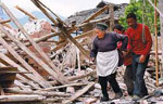
 Relief reaches isolated village
 Rainfall poses new threats to quake-hit region
 Funerals begin for Boston bombing victims
 Quake takeaway from China's Air Force
 Obama celebrates young inventors at science fair
 Earth Day marked around the world
 Volunteer team helping students find sense of normalcy
 Ethnic groups quick to join rescue efforts
Most Viewed
Editor's Picks
|
|

|

|

|

|
Today's Top News
Health new priority for quake zone
Xi meets US top military officer
Japan's boats driven out of Diaoyu
China mulls online shopping legislation
Bird flu death toll rises to 22
Putin appoints new ambassador to China
Japanese ships blocked from Diaoyu Islands
Inspired by Guan, more Chinese pick up golf
US Weekly

|

|