Rising lake levels threaten to flood major railway line
Updated: 2014-06-14 08:24
By Zheng Jinran (China Daily)
|
||||||||
Rising lakes in Qinghai province may affect the safety of the nearby high-elevation Qinghai-Tibet Railway, experts said, as they called for joint efforts between departments to prevent possible damage.
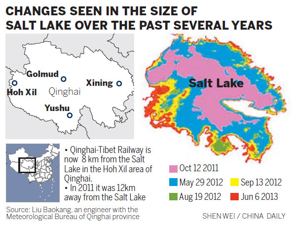
"The railway is now only 8 km from the Salt Lake in the Hoh Xil area of Qinghai, down from 12 km in September 2011," said Liu Baokang, an engineer from the Satellite Remote Sensing Center under the Meteorological Bureau of Qinghai province, on Friday.
The weather in the Qinghai-Tibetan Plateau is becoming wetter and hotter in summer, resulting in steadily increasing rainfall in July and August, according to provincial meteorological records.
The coming flood season will thus push the water level higher, possibly extending the Salt Lake closer to the major rail line, which links Xining, Qinghai province, and Lhasa, the Tibet autonomous region, he said.
In the Hoh Xil area in southwestern Qinghai, four inland lakes, including the Zonag Lake in the west and the Salt Lake in the east, were linked by flooding after a natural dam break of Zonag Lake in September 2011, an event that experts believe was triggered by two nearby earthquakes.
Due to the dam break, about 5 billion cubic meters of water, equal to 485 West Lakes in Hangzhou, Zhejiang province, were discharged from Zonag Lake, located in the higher western area, flowing to the two lakes nearby.
Flooding from the three lakes converged on the Salt Lake in the lower eastern area, quickly expanding its surface area from about 46 square km before the dam break in 2011 to around 142 sq km in 2014.
In addition to posing a possible danger to the railway, the expanding lake surface may create problems in telecommunications in the area.
"The Salt Lake contains a higher salt concentration, and the salty water could corrode the communication optical cables nearby," Liu said. The government needs to take action to avoid damage to the telecommunications and railway systems, he added.
Obtaining a more accurate analysis of the direction of the lake's expansion requires a map reference that can give the topographical situation of the lake and surrounding areas to within 20 meters. Such information is available only from the province's mapping bureau, Liu said.
"We urgently need to cooperate with the bureau to share the accurate topographic information in order to release the targeted measures," he said.
Zheng Jie, deputy head of Qinghai province's forestry department, said the government began to keep a closer eye on the increasing surface of the Salt Lake to protect the safety of the railway and other tunnels, China News Service reported.
A professional team conducted a field investigation and handed in a response report to the central government in 2013, the deputy head said.
But Liu said the experts did not agree on whether to rebuild the broken dam, and the authority has not taken any action.

 Obama visits native American reservation
 Clinton has reasons to run at her ready
 Angelina Jolie shines at summit against sexual violence
 Railroad photo shows Asian-Americans
 Across Americas
 US law firm awards fellowship to students in China
 Museum focuses on immigrants
 Bush senior marks 90th birthday with a skydive
Most Viewed
Editor's Picks

|

|

|

|

|

|
Today's Top News
Envoy rebuts Vietnam, Philippines on sea issue
Obama faces limited options in Iraq crisis
Oregon high school shooter's parents offer apology
Army: Bergdahl 'looked good' after returning to US
Cui: China poses no threat to US
Japanese F-15 tails Chinese jet at close distance
Zhaopin's IPO raises $76m, company brand
Xi's call for 'energy revolution' supported
US Weekly

|

|