Chasing vestiges of the great wall
Updated: 2013-04-23 08:08
By William Lindesay (China Daily)
|
||||||||
|
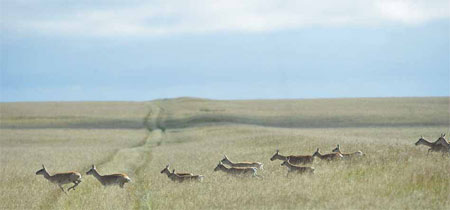
Gazelles cross the Genghis Road, which follows the Wall of Genghis Khan, now a mound that runs across the Eastern Steppe in Mongolia. Chen Xinyu / for China Daily |
|
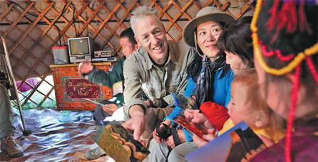
William Lindesay and his wife, Wu Qi, show Mongolian herders postcards of a more familiar Great Wall, near Beijing. James Lindesay / for China Daily |
|
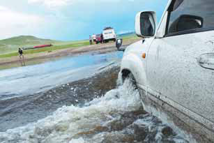
The expedition has to cross a flooded and boggy Henti province before reaching the drier region of the Eastern Steppe. William Lindesay / for China Daily |
|
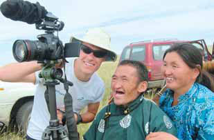
Cameraman David Watson shows video footage to herders on the Eastern Steppe in Mongolia. Wu Qi / for China Daily |
Explorer William Lindesay undertakes an expedition into the Eastern Steppe to answer questions about the origins of the 'Wall of Genghis Khan'.
Enter the coordinates N49.50', E116.42' into Google Earth and you'll find a place where the borders of China, Mongolia and Russia meet. Around it you'll discover a linear structure, more than 600 km long, that pays no heed to those national borders. Or, it may have been the very first border control in the region. To some, the structure constitutes the remains of a wall; to others, it's a trench and mound; and to others still, a road. Yet one thing is apparent: It runs from southwest to northeast without any significant breaks, though its name changes as it goes.
In Mongolia, it's known as the "Chinggisiin Kherem Zam" (Genghis Khan Wall-Road), in China it's called the "Jin Jie Hao" (Jin Dynasty Trench-Mound) and in Russia it's the "Val Chingis Khana" (Genghis Wall).
The longest part of the structure lies within Mongolia, and it became the latest destination in my quest to understand the Great Wall.
In the summer of 2011, I organized my first Genghis Khan Wall expedition to Mongolia's Omnogovi, or "South Gobi" province, and used radiocarbon dating to prove that the wall there dates back to the Western Xia Dynasty, built between the 11th and 12th centuries.
Maps of Mongolia name seven separate portions of this structure the "Wall of Genghis Khan". Located along various compass directions, they have provided me with a few years' worth of expedition material and varied landscape challenges.
Last summer's second expedition promised to be a very different journey, as it would take me and my companions from the Mongolian capital of Ulan Bator, through the country's largest expanse of steppe, to the Mongolia-China border.
The wall on the Eastern Steppe is the most northerly and the most controversial in origin. Sources point to its three possible architects: the Liao (916-1125), the Jin (1115-1234) and, as suggested by its name, Genghis Khan's Yuan Dynasty (1271-1368).
The Official History of Liao mentions the "Border Defense Fortifications", with cavalry deployed along a 750 km length of defenses. It was reportedly built "to make safe land at Jing Bian Cheng, the home of more than 20 tribes united by the Liao, and protect life against the hostilities of the Yujue and Shiwei (tribes)".
Historical atlases also show the northern edge of Liao territory running exactly along the line of the Eastern Steppe's Genghis Khan Wall.
In favor of the Jin is a reference in The Official History of the Jin, mentioning the existence of "Bian Bao" or "Bian Pu", which mean "Border Forts".
Finally, The Secret History of the Mongols, written in the early 13th century, leave some cryptic clues that could be interpreted as reasons for building walls, fences and post stations.
"I established post stations so that our messengers can gallop swiftly toward their goal and transport our necessities," Genghis Khan's son and successor, Ogodei (1185-1241), said.
"Being covetous, and fearing that the wild beasts, born with their destiny determined by Heaven and Earth, would advance onto the lands of my brothers, I had fences and walls of pounded earth constructed," he said.
The leader gave this order despite knowing it was a grave sin. The building of any restraining structure, such as a wall, would have been considered an offense against divine law in Mongol culture, as it interfered with the flow of nature.
Looking for clues
My team drove northeast through the hills and swollen rivers of Henti province for two days before reaching the edge of the Eastern Steppe.
It was dry, sunny and cool as we followed a track pressed into deep grass. This is Mongolia's best type of road in my opinion: made by use, not made to be used.
Amid this ocean of grass I hoped to pick up the most westerly remains of the Genghis Khan Wall. I had GPS and sheets of very detailed maps on which each thumbnail showed 2 km of territory, but where was the start of the wall?
In previous expeditions - through deserts, hills and mountains - I'd scrutinize the landscape in all directions by looking for the wall's defining characteristic: linearity. Here, it was quite different. In the expanse of green, there was nothing to really focus on, little to provide any depth of field.
We eventually discovered the wall by finding its "shadows". A track, a shallow trench and a slight mound stretched side by side, across the steppe, into the horizon.
In Mongolia's wilds, which was sparsely inhabited and devoid of landmarks, early travelers created markers by piling stone upon stone. These structures grew little by little, higher and higher, as more explorers followed in their footsteps.
These Mongolian markers, called "ovoos", eventually assumed religious significance outside their practical use. This amazing structure running across the steppe, inviting people to follow it, became known as "Kherem Zam", or "Wall Road".
When I turned around, out of nowhere, about a dozen horses were making their way toward the wall. Led by a handsome gray, the majestic animals approached. They strutted across the darker grass of the trench to the crown of the mound, pausing to look, nod their heads and swish their tails.
I stood transfixed. I couldn't have expected a finer welcome at the Eastern Steppe's Wall of Genghis Khan.
My companions and I camped nearby, just a few hundred meters inside the line of the wall, beside a walled square. These, we found, had been established along the structure's entire length, and might have acted as barracks and post stations for messengers.
"Huge herd of gazelles on the right - 3 o'clock!" the radio crackled.
Using binoculars, I followed the directions. I panned forward but could not reach the front of the herd before losing the animals over the skyline. Panning back through 3 km of steppe, I saw several thousand of them galloping.
We drove on and soon crossed paths with the gazelles. Across the wall, the trench and the road, they sped right in front of us. At that moment, the animals showed us how useless a trench-mound structure would have been to stop them in their path.
At the same time, I could imagine the drama, and later the carnage wrought by Ogodei's palisade, his archers standing behind it with their bows drawn.
I'd invited biologist Kirk Olson to join the expedition because he lived in a yurt on the steppe for five years while researching gazelles.
Olson asked me about gazelle sightings I'd made in China. He also asked me how far was it possible to drive across the Inner Mongolian steppe before encountering something - a vehicle, a building and a fence.
Under threat
I'd seen one or two gazelles on a couple of occasions. In Inner Mongolia it was difficult to come across total emptiness. There was always something to see or something going on: gravel and sand digging, trucks driving by, buildings, power lines, new towns in the middle of nowhere.
"The Eastern Steppe is the last refuge for gazelles," Olson says. "As their habitat shrinks, so does their population, from an estimated 15 million during the Genghis Khan period to less than 1 million now, and it's dwindling at a rate of 100,000 per year."
Hunting is permitted, with a license and with a quota, but illegal hunting is common. Olson is also concerned with new threats like fences, which block migrations.
"Fences along the border and railway lines pose serious obstacles," he says. "They could block escape routes for herds, when, for example, they encounter extreme weather conditions or get spooked by something such as a grassland fire. Big mining corporations have already begun to explore land on the edge of this last refuge."
It's obvious to anyone who comes to the Eastern Steppe that the place is a unique combination of history and nature, which for its ecology, beauty and fragility, urgently deserve recognition as a World Heritage site.
How much longer will great wildernesses and their fauna be decimated by those whose blindness lures them into thinking that such abundances will be eternal?
As it had been for more than 400 km, we were still driving beside the trench and mound.
Walking the last 100 meters of the wall, I had a flashback of the long drive across the steppe. Rather than reach the end of the road with a singular conclusion about the origin of the Genghis Khan Wall, I favored plural, overlapping possibilities.
Built by the Liao, inherited and refitted with fortresses by the Jin, the wall was reinvented during the reign of Ogodei as a post road and bolstered by palisades to prevent gazelles from migrating. It might well have functioned as a "Wall for Three Peoples", as well as now being a "Wall of Three States".
A gray rock post stood 20 meters short of a barbed wire fence. I could now clearly see the Genghis Khan Wall going under the fence, across a tract-plowed land acting as a firebreak, and emerging on the other side as the Jin Trench-Mound.
The rock post was etched with "Mongolia" in Cyrillic script. The army commander who had escorted us into this restricted zone had warned me not to go past it, but I so yearned to see written evidence. I leaned forward, not stepping beyond the border. But that was just enough to confirm that the rock's reverse bore in red characters the word "China".

 'Taken 2' grabs movie box office crown
 Rihanna's 'Diamonds' tops UK pop chart
 Fans get look at vintage Rolling Stones
 Celebrities attend Power of Women event
 Ang Lee breaks 'every rule' to make unlikely new Life of Pi film
 Rihanna almost thrown out of nightclub
 'Dark Knight' wins weekend box office
 'Total Recall' stars gather in Beverly Hills
Most Viewed
Editor's Picks

|

|

|
|

|

|
Today's Top News
Sluggish growth takes its toll on foreign lenders
Investors find a home in overseas real estate
More Chinese travel overseas, study reveals
Xi meets former US heavyweights
Li in plea to quake rescuers
Canada to return illegal assets
Beijing vows to ease Korean tensions
Order restored after deadly terrorist ambush
US Weekly

|

|